Learning Objectives - After completing this class you’ll be able to properly prepare your data for upload to eSpatial.
The following video will give you a run through of how to prepare your data for upload to eSpatial. Each part of the video will then be broken down below.
Format
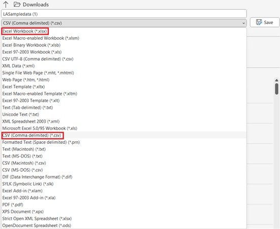
Before uploading your data to eSpatial, you should ensure it is in the correct format. To upload a dataset to eSpatial, it needs to be in Excel or CSV format. When saving, click on the file drop down menu, select save as and choose Excel Workbook (*.xlsx) / (*.xls) or CSV (Comma delimited).
First Sheet
Only data in the first sheet of your spreadsheet will be recognized when uploading to eSpatial. To make sure all the data you need gets uploaded, ensure it is within the first sheet.
Column Headers
Ensure your column headers are in the first row as eSpatial will recognize your first row as the header row. If the first row/s in your dataset are blank, then an error will occur when uploading your spreadsheet.
%20Sample%20Data%20Header%20SS.png?width=670&height=127&name=(Class%201)%20Sample%20Data%20Header%20SS.png)
Location Data
For your data to plot on a map it needs to contain location information which can either be an address or coordinates. An address could be in a single column as the full address or it can be split into parts e.g. Street, City, ZIP, State and Country.
%20Sample%20Data%20Location%20SS.png?width=670&height=127&name=(Class%201)%20Sample%20Data%20Location%20SS.png)
We suggest including as much address/location information as possible to ensure your data plots more accurately. However, we recommend that you do NOT include address information such as Business/Building names, Apartment numbers, Suite numbers or P.O. Boxes.
Now that you have successfully prepared your data, you are ready to start uploading to eSpatial.